Map Products & Collections
MAPS THAT
TELL STORIES
Three distinct product lines — agricultural heritage, historical cartography, and environmental mapping. Each section includes a quote request form so you can get pricing without leaving the page.
Agricultural Heritage Series
Coffee & Wine
Region Maps
Our flagship agricultural heritage collection combines contemporary satellite precision with the artistry of traditional cartography. Each map captures the terroir, microclimates, and regional boundaries that define the world's most celebrated growing regions.
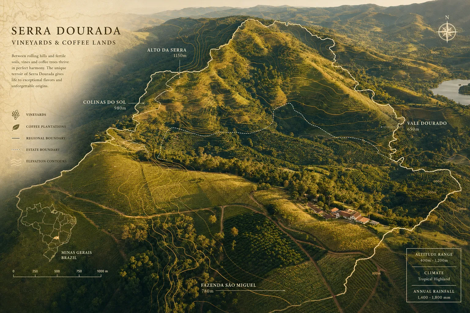
World Coffee Origins Atlas
BestsellerComprehensive mapping of all major coffee-growing regions — from Ethiopia's Yirgacheffe highlands to Colombia's Huila department. Includes elevation data, variety distribution, and harvest season overlays.
Global Wine Regions Collection
NewA definitive cartographic survey of the world's wine appellations — from Bordeaux to Barossa Valley. Contemporary boundaries, soil type overlays, and historical appellation evolution.
California Wine Country Series
Detailed mapping of Napa, Sonoma, Paso Robles, and Central Coast AVAs with vineyard-level precision. Includes geology, water features, and fog line analysis.
Single-Origin Coffee Estate Maps
CustomCustom cartographic portraits of individual coffee estates and cooperatives. Perfect for specialty roasters, direct trade programs, and origin storytelling.
GET PRICING FOR THIS COLLECTION
Fill in the details below and we'll send a tailored quote within 1–2 business days.
Historical Cartography Series
The Holy Lands
Collection
Our Holy Lands collection represents the pinnacle of historical cartographic art — maps that honor the ancient tradition of sacred geography while incorporating modern GIS accuracy. Each piece is a work of scholarship and artistry, suitable for institutions, collectors, and houses of worship.
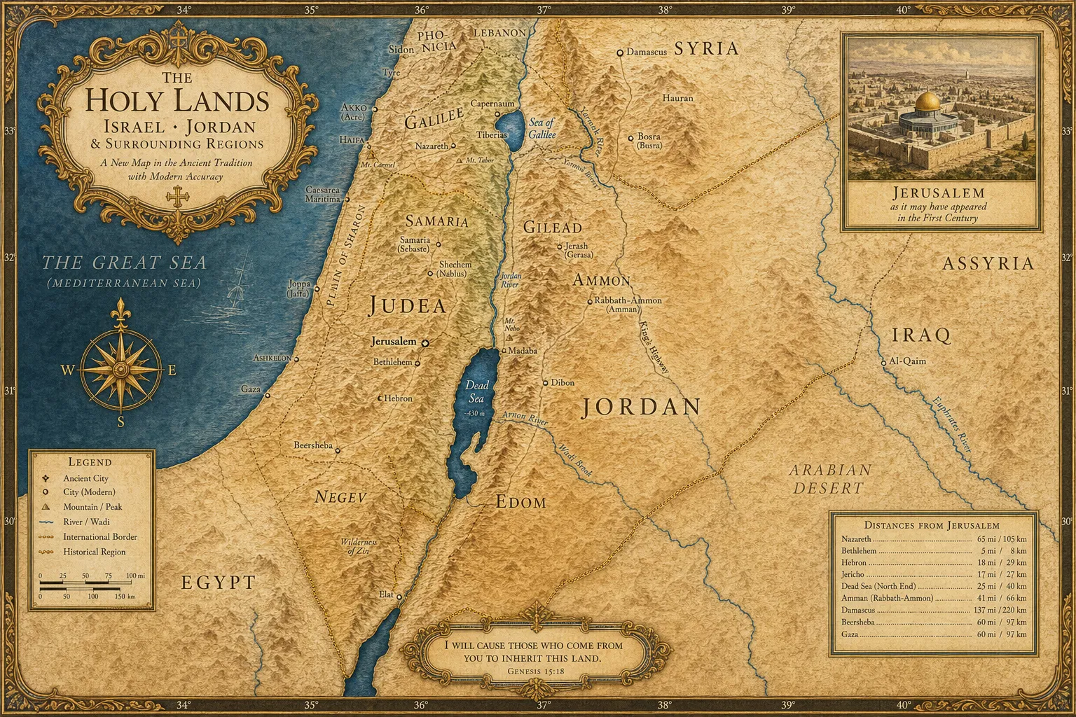
The Holy Lands — Master Map
SignatureOur signature piece: a richly detailed map of Israel, Jordan, Lebanon, and surrounding regions in the classical cartographic tradition. Features ancient and modern place names, topographic relief, and sacred site markers.
Biblical Israel — First Century
A scholarly reconstruction of the Holy Land as it appeared during the first century CE. Includes Roman administrative boundaries, trade routes, and archaeological sites.
Ancient Near East Historical Atlas
NewA comprehensive multi-map atlas tracing the geopolitical evolution of the region from the Bronze Age through the Ottoman period. Twelve maps with scholarly annotations.
Custom Pilgrimage Route Maps
CustomBespoke maps for religious organizations, pilgrimage tour operators, and educational institutions. Custom routes, site annotations, and institutional branding.
GET PRICING FOR THIS COLLECTION
Fill in the details below and we'll send a tailored quote within 1–2 business days.
Environmental & Community Series
Environmental &
Community Mapping
Our environmental and community mapping products serve land trusts, conservation organizations, municipalities, and community planners. These maps translate complex environmental data into accessible, decision-ready formats that engage stakeholders and support informed governance.
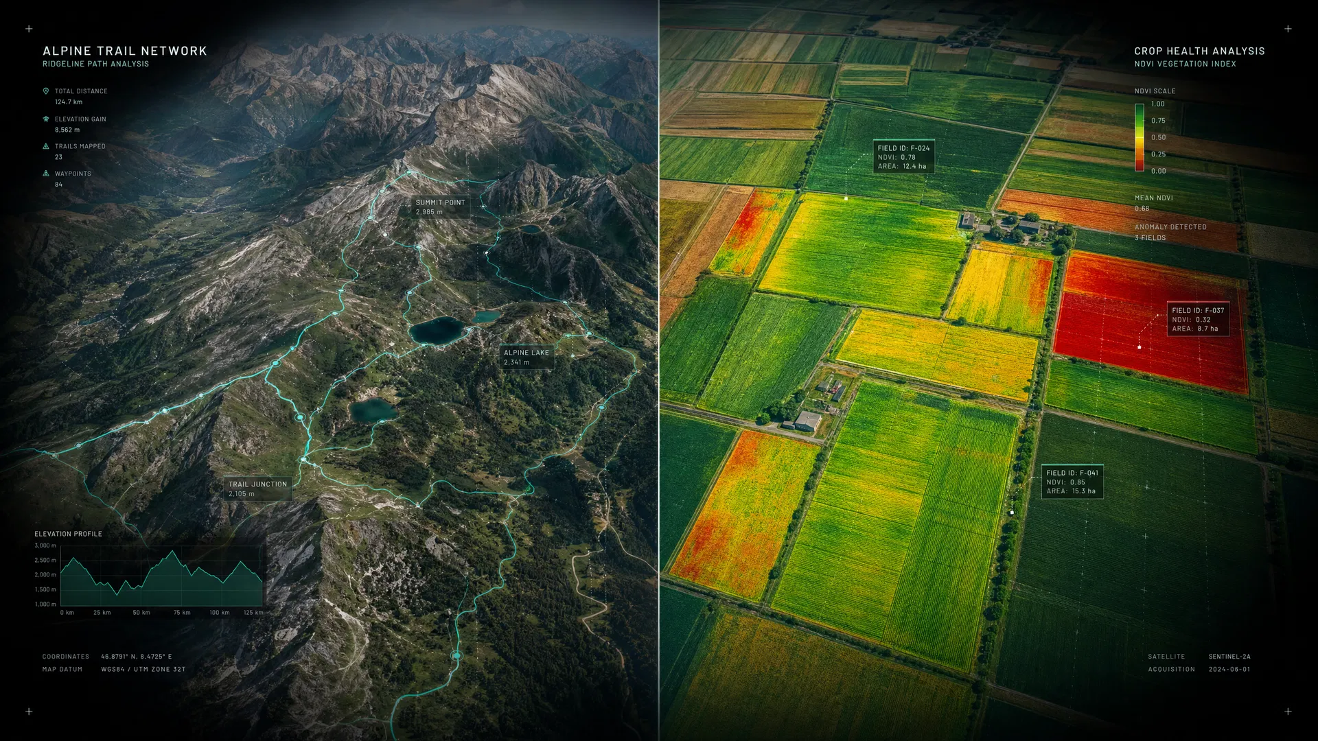
Watershed & Riparian Corridor Maps
Detailed mapping of watershed boundaries, stream networks, floodplains, and riparian buffers. Essential for conservation planning, stormwater management, and regulatory compliance.
Community Asset & Vulnerability Maps
Spatial analysis of community infrastructure, social vulnerability, and environmental justice indicators. Used by municipalities, NGOs, and emergency management agencies.
Conservation Land Trust Atlases
PopularComprehensive mapping of protected lands, easements, and conservation priorities for land trusts and conservation organizations. Includes stewardship monitoring overlays.
Custom Environmental Impact Maps
CustomTailored mapping products for environmental impact assessments, NEPA documentation, and regulatory submissions. Meets all agency cartographic standards.
GET PRICING FOR THIS COLLECTION
Fill in the details below and we'll send a tailored quote within 1–2 business days.
Custom Map Services
DON'T SEE
WHAT YOU NEED?
Our custom mapping services team can create virtually any geospatial product you can imagine. From bespoke wall maps for corporate headquarters to interactive web atlases for public engagement — we bring your vision to life with scientific precision and artistic excellence.
Request a Custom MapAny Region
Global coverage — from local neighborhoods to continental scales
Any Style
Scientific, artistic, historical, or hybrid — we match your vision
Any Format
Print, digital, interactive web, GIS data, or all of the above
Any Scale
Single maps to large-format atlases and enterprise data products
WE VALUE YOUR PRIVACY
We use cookies and similar technologies to operate this website, remember your preferences, and — with your consent — collect anonymized analytics to improve our content. We never sell your data. Privacy Policy