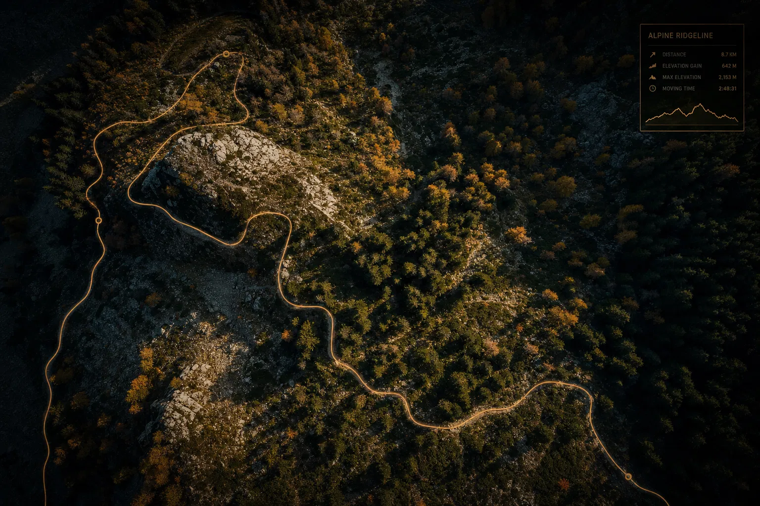
Trail Design Systems
"Terrain intelligence that shapes exceptional trail experiences"
We combine LiDAR terrain analysis, ecological sensitivity mapping, and stakeholder engagement to design trail networks that are sustainable, accessible, and extraordinary to use.
The Challenge
Land managers face mounting pressure to expand recreational access while protecting sensitive ecosystems, managing erosion risk, and meeting ADA compliance requirements — all with limited budgets and staff.
Our Approach
Coast Map Labs delivers end-to-end trail design support: high-resolution terrain modeling from LiDAR data, slope and aspect analysis, vegetation and soil sensitivity mapping, alignment optimization, and full regulatory documentation packages.
Outcomes Delivered
- Optimized trail alignments that minimize environmental impact
- ADA-compliant accessible route identification
- Erosion risk scoring and mitigation planning
- Stakeholder-ready visualization and engagement materials
- Permit-ready environmental documentation
Ready to explore what Trail Design Systems could look like for your organization?
"Terrain intelligence that shapes exceptional trail experiences"
We combine LiDAR terrain analysis, ecological sensitivity mapping, and stakeholder engagement to design trail networks that are sustainable, accessible, and extraordinary to use.
The Challenge
Land managers face mounting pressure to expand recreational access while protecting sensitive ecosystems, managing erosion risk, and meeting ADA compliance requirements — all with limited budgets and staff.
Our Approach
Coast Map Labs delivers end-to-end trail design support: high-resolution terrain modeling from LiDAR data, slope and aspect analysis, vegetation and soil sensitivity mapping, alignment optimization, and full regulatory documentation packages.
Outcomes Delivered
- Optimized trail alignments that minimize environmental impact
- ADA-compliant accessible route identification
- Erosion risk scoring and mitigation planning
- Stakeholder-ready visualization and engagement materials
- Permit-ready environmental documentation

"Satellite intelligence that transforms how farms make decisions"
We harness multispectral satellite imagery, drone surveys, and IoT sensor data to give producers field-level visibility into crop health, soil variability, and yield potential — at any scale.
The Challenge
Agricultural producers operate on thin margins in an era of climate volatility. They need precise, timely spatial intelligence to optimize inputs, detect stress early, and demonstrate environmental stewardship to buyers and regulators.
Our Approach
Our precision agriculture practice delivers NDVI and multispectral crop health mapping, soil variability analysis, prescription zone mapping, irrigation optimization modeling, and carbon sequestration measurement — all integrated into the platforms producers already use.
Outcomes Delivered
- Early detection of crop stress, disease, and pest pressure
- Variable-rate input prescription maps (fertilizer, water, seed)
- Yield prediction and post-harvest analysis
- Regulatory-grade carbon and water stewardship reporting
- Integration with farm management software (John Deere, Trimble, etc.)

"GIS-powered intelligence for the infrastructure that powers modern life"
We help electric, gas, water, and telecom utilities build enterprise GIS platforms that transform asset data into operational intelligence — enabling predictive maintenance, regulatory compliance, and grid modernization.
The Challenge
Aging infrastructure, regulatory pressure, and the energy transition are forcing utilities to modernize asset management. Most organizations have fragmented data across legacy systems, making it nearly impossible to achieve the spatial visibility needed for proactive management.
Our Approach
Coast Map Labs designs and implements enterprise GIS environments that consolidate asset data from SCADA, CMMS, and field systems into a unified spatial platform. We deliver asset inventory programs, condition assessment frameworks, predictive maintenance models, and outage management integrations.
Outcomes Delivered
- Unified enterprise GIS with real-time asset visibility
- Predictive maintenance models reducing unplanned outages
- NERC/FERC and state regulatory compliance documentation
- Integration with SAP, Oracle, IBM Maximo, and Esri platforms
- Digital twin foundation for grid modernization programs

"Connecting spatial data to the systems that run your business"
We integrate GIS platforms with enterprise systems — ERP, CMMS, SCADA, CRM — creating unified data environments that eliminate silos and enable spatial intelligence at every level of the organization.
The Challenge
Geospatial data only creates value when it flows seamlessly through an organization's technology ecosystem. Most enterprises have GIS data locked in isolated platforms, disconnected from the business systems where decisions are made.
Our Approach
Our integration practice designs and builds bidirectional data pipelines between GIS platforms and enterprise systems. We develop custom APIs, spatial data services, and real-time synchronization workflows — and we specialize in digital twin architectures that create living, spatial representations of physical assets.
Outcomes Delivered
- Real-time GIS-ERP data synchronization
- Custom spatial APIs and data services
- Digital twin platform development and deployment
- Cloud migration and platform modernization
- Automated reporting and regulatory submission workflows
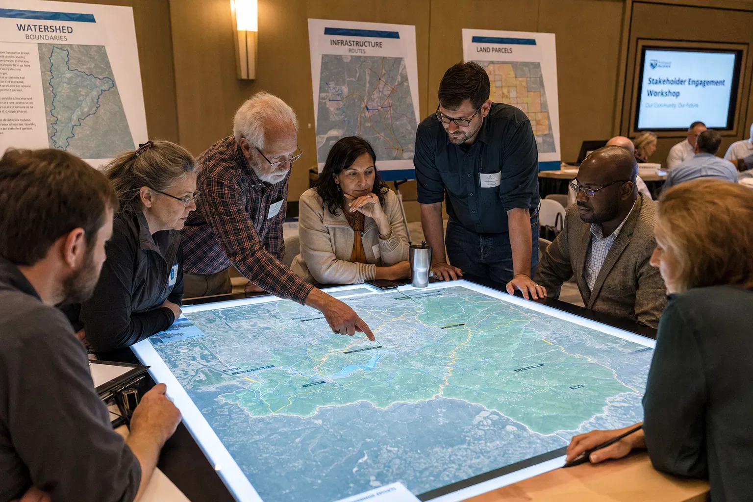
"Translating spatial complexity into decisions communities can trust"
We specialize in bridging the gap between technical geoscience and the humans who must act on it — from utility regulators and elected officials to farmers, conservation advocates, and frontline workers.
The Challenge
Even the most technically excellent geoscience program fails without effective stakeholder alignment. Organizations routinely underestimate the human dimension of spatial data initiatives — the need to build trust, navigate competing interests, and communicate complex findings to non-technical audiences.
Our Approach
Coast Map Labs brings structured facilitation, visual communication, and deep subject-matter expertise to every stakeholder engagement. We design participatory mapping workshops, produce accessible data visualizations, develop regulatory briefing packages, and build the internal advocacy needed to move programs forward.
Outcomes Delivered
- Stakeholder mapping and influence analysis
- Participatory mapping workshops and public meetings
- Regulatory and permitting documentation support
- Executive and board-level briefing materials
- Community-facing interactive map applications
- Training programs that build lasting internal capability
WE VALUE YOUR PRIVACY
We use cookies and similar technologies to operate this website, remember your preferences, and — with your consent — collect anonymized analytics to improve our content. We never sell your data. Privacy Policy